Before the California Gold Rush, there was the Lake Superior Copper Rush. Elemental copper was so bountiful in places along the southern shores of Lake Superior, especially the Keweenaw Peninsula, that it was widely harvested by the native inhabitants and became part of the trade networks in pre-Columbian North America. Even in prehistoric times, Lake Superior copper was found as far away as Alabama.
In 1842 the US government signed a “treaty” with the resident Ojibwe tribes to access this copper. Under the Treaty of La Pointe (that’s the town on Madeline Island we visited last weekend) the Ojibwe only surrendered mineral rights across the southern shore of Lake Superior, and retained the right to hunt, fish, and live on the land. But like so many other treaties, the native parties ended up with a lot less than they bargained for. The copper rush of the 1840s led to an influx of white settlers that effectively put the lands off limits to the Ojibwe people and made the remote Keweenaw Peninsula a hive of commercial activity.
Over 4 billion (not a typo!) pounds of copper were extracted from the Calumet conglomerate on the Keweenaw Peninsula using 19th century mining technology. That was possible in part because the copper deposits were so large and pure. Back in April when I visited the Smithsonian Museum of Natural History, I spotted an interesting object in the hall containing special treasures: a 5 foot long sheet of copper extracted in a single piece from one of the mines on the Keweenaw. While normal visitors were oohing and aaahing over the Hope Diamond in the middle of the room, I (a super-nerd) was over on the side reading all about copper mining in anticipation of our summer travels to this area. So it came as no surprise when we started seeing the familiar shapes of mine structures as we made our way north up the peninsula. The Keweenaw Heritage Sites offer numerous opportunities to visit underground mines, mine head structures, and ghost towns along the peninsula.


Fort Wilkins State Historic Park
Anticipating the rush of miners, the federal government established Fort Wilkins in 1844 near the town of Copper Harbor on the very tip of the Keweenaw Peninsula. The natural harbor on Lake Superior and the known presence of large copper deposits nearby made this a good spot for a federal presence that would handle mineral lease filings and attempt to manage conflicts between the immigrant miners and native inhabitants. The fact that this area was only accessible by water half the year, and the next closest Army facility was Fort Brady, 250 miles away in Sault St. Marie, made this a pretty terrible place to be posted. Supplies only came in summer, and in winter the only connection with the outside world was mail bought by dogsled from Fort Howard in present-day Green Bay, WI.


The preserved and reconstructed buildings at Fort Wilkins State Historic Park do a nice job telling the story of the people who served at the fort for the quarter century it was active, from 1844 to 1870. The period furnishings in the officers and enlisted quarters, along with fully equipped work areas like the bakery, kitchen, blacksmith shop, infirmary, and commissary, make for an immersive experience.
Where We Stayed
In addition to the historic military structures, the state park also has two campgrounds and we stayed in the West Campground. Quarters were a little tight, to say the least. Sites are perpendicular to a very narrow driveway and the hefty fire pits are placed in odd spots, creating an obstacle to parking. Although our space was rated for a 35 foot trailer (and we are 25 feet long) it would have been geometrically impossible to get into our spot without our neighbor across the street moving his truck while we parked. There is a new section with 50 amp service, which we don’t require, but after seeing those much larger and well-designed sites I regretted not trying to book one of those.


Once we were finally situated we could enjoy the park’s other amenities: access to a large inland lake (amusingly named Fanny Hooe – I don’t know how to say it but any conceivable pronunciation of that name cracks me up), a historic lighthouse, and trails connecting all the different areas that were lined with ripening thimbleberries and blueberries. Yum! We intended to put the kayak into the inland lake, but were thwarted by high winds during our stay. Instead we walked all the trails in the park on several different days, admiring the little lake, the huge lake, and the forests full of birds, chipmunks, and red squirrels.


Disconnected from the World
The road to Copper Harbor – there is only one — is winding, scenic, and seemingly endless. If we followed US 41 for about 2,000 miles to its other end we would end up in Miami! There is also not a whisper of cell service on AT&T in the Copper Harbor area. We expected this coming in, but after seeing the bustling little town full of hotels and shops I was a little confused. Our home is on a barrier island 4 miles off the mainland with fewer than 1,000 residents, and we have 5G service on multiple carriers plus high speed cable internet. I wonder what the locals here have done to anger the cellular gods. In any case we really empathized with the isolation of the soldiers posted to Fort Wilkins in the 19th century. We had to resort to the techniques we honed back in our days in the mountain West, such as making trips to mountaintop viewpoints – ostensibly to take in the view – and sending a flurry of texts when we discovered a few miraculous bars of service.


Our campground offered painfully slow wifi, and it was only available in the immediate vicinity of the bathhouse, which led to a persistent crowd of people clustered around the bathrooms staring at their phones. On a day I needed to participate in a video call, we drove 30 miles down the peninsula to the closest town with decent cell service (Mohawk). As a bonus, while there we were able to get gas at a station with pumps that didn’t look like ancient artifacts. To amuse ourselves in the evenings, we pulled out our emergency pack of DVDs. For younger readers, I should explain that this is a 20 year old technology in which one inserts a “disc” into a “player” device in order to stream 20 year old movies onto the screen.
Scenes Around Copper Point
Despite some of the drawbacks of the area, we managed to find plenty of scenic spots to visit. Our best long-distance views came from Brockway Mountain Drive, a narrow, lumpy road that seems to go straight up the side of a cliff before running along the top of a ridge toward the town of Eagle Harbor. Numerous overlooks and pull-offs provide sweeping views over the town of Copper Harbor, the Copper Range to the south, and Lake Superior to the north.


Our best forest experience came in the Estivant Pines Nature Sanctuary, a 570 acre tract preserving one of the last old-growth white pine stands in Michigan. The sanctuary is just 3 miles from Copper Harbor, down yet another tiny unpaved road with axle-busting potholes and very limited signage. Although Google navigation has tried to kill us on several occasions, I’d rather have it than not. In any case, once we located our destination we hiked two loops of trail totaling 2.5 miles through stands of towering trees. It’s no wonder these immensely tall, ramrod-straight trees were so valued by the timber industry. It reminded us a bit of the Redwoods, right down to the terrible access road.


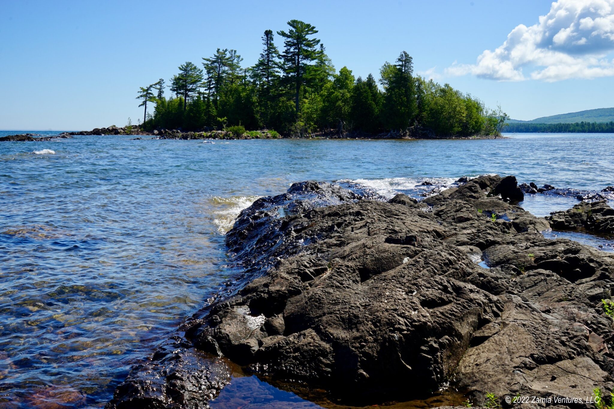
Our best Lake Superior and beach views came from hiking at Hunter’s Point Park located just west of town. The trails here are measured in feet rather than miles (3,000 feet to be precise) but offered an unparalleled opportunity to enjoy both the rocky “beaches” of Superior and views of the town’s calm natural harbor.


We had considered using this stop as a base to travel to remote Isle Royale National Park, but we were put off by the three-hour boat ride (each way) required to visit the island for just under three hours. Isle Royale will remain unvisited by us for the foreseeable future. Instead we went down to the Isle Royale departure dock and visited Jamsen’s bakery, which has been serving Finnish-influenced baked goods since 1954. The donuts with thimbleberry icing and the savory scones were delightful.


This should be our only stop of the trip with nonexistent connectivity, and we’re happy it was a short one. That being said, seeing forests dominated by pines and firs while being off the cellular network – and making frequent use of the 4-wheel drive feature on our truck — made us feel that we had really experienced a bit of the North Country.
Next: we continue east to Munising to visit Pictured Rocks National Lakeshore.

I find it both peaceful and exasperating to be without connectivity for a few days. Mostly exasperating, LOL. We’ll be in Copper Harbor for only three nights, but it sounds like we’ll have plenty to do while we’re there. Like you, we’ve decided against visiting Isle Royale NP. It’s tempting, but just not worth the long boat ride and the very short time on the island. And if there’s bad weather, they cut your time on the island short!
You certainly found beautiful scenery that you captured very enticingly in your photos. The name Lake Fanny Hooe cracks me up, too…I looked it up and the correct pronunciation is “ho.” Which I am sure you already know. 😂😂
I really enjoy all of the little tidbits you include in your posts, like that you could drive all the way from Copper Harbor to Miami on US 41. Or that you saw a 5-foot sheet of copper at the Smithsonian that came from the Keweenaw Peninsula. We’re looking forward to our visit there, and hoping three nights will be enough. Thanks for the great info! I’m taking notes, especially since I will not be able to consult your posts once we’re there in the land of no-connectivity.
Two days is plenty of time to explore Copper Harbor, especially if you stay in the immediate vicinity of town like we did. You may even have time to explore some of the art galleries and shops, which we did not. I think the thing I find most annoying about the lack of connectivity is not being able to check the weather forecast, especially since it is so unpredictable on the UP. Also the lack of mapping. And not being able to look up things like business hours. OK, there are plenty of things I dislike. I seriously wonder how the full time residents manage.
I hope you can get your boat out onto Lake Ho! It’s really lovely, but there was no way we were going to battle 20 mph winds. In calm conditions it would make for a great paddle, and there are several different access points with easy entry.
The whole lack of connectivity thing is just nuts to me. It’s not just some fun convenience these days. it is absolutely essential to modern life.
How do people self diagnose their aching arm and convince themselves they’re dying because WebMD says so? How do people find out which Kardashian just got divorced for the 7th time and which one is now pregnant with their ex-boyfriend’s 12th child? How do they live life without spending 22 hours a day watching “just one more” video about completely irrelevant nonsense on Youtube?
I joke, but seriously – the internet is a necessity and I find it utterly insane to be in these remote locations with no way to seek help. We’ve needed it before and, as beautiful and relaxing as it might seem to be off-grid, I’d never be comfortable in that environment for more than a couple days. These folks are hardier than me, I guess. God bless em.
I am with you on this. I understand that weekend campers might like the opportunity to disconnect for a few days, but I have no idea how people who live in this area full time get by. Maybe they have satellite connections. And even though we are “only” part time travelers rather than full-time, I really would have liked to stay connected in order to do planning for our next stop, in addition to the comfort of having Google maps at hand. And verifying the check-in time at our next campground, and the route we will take to get there, etc. I agree with you that navigating the modern world is almost impossible without an internet connection, and trying to travel while being disconnected is even harder. I am hearing good things about Starlink, especially for use out west, so that’s encouraging news about some of the really remote places. Copper Harbor just needs to get connected to the rest of the peninsula on which it sits, which doesn’t seem like it should be so hard.
Being off the grid sounds absolutely heavenly. I actually miss having zero connection sometimes, and I know I’m really, really old when I shake my head and think, “Oh, those whippersnappers and their fancy gadgets.” Had the world taken a different turn, we would have been coming through the U.P. in the fall rather than the spring, and surely would have taken in the Keweenaw. We sent many a traveler that way from the NGLVC. I spent too much time trying to figure out what an Estivant Frog was, and that bottom-right donut looks a bit…sketchy. Time for a pasty!
See, if we had internet I could have researched what type of frog/toad we saw at Estivant Pines and you would not have been frustrated. 🙂 I will say that the mining heritage of the Keweenaw is still evident in an overall vibe of grittiness. It reminded me of Butte, Montana. It’s interesting how these long-gone industries cast such a long shadow. Oh, and the thing with the donuts is that there are two kinds: yeast-raised and cake, and they ice them differently. I am all for donut diversity!