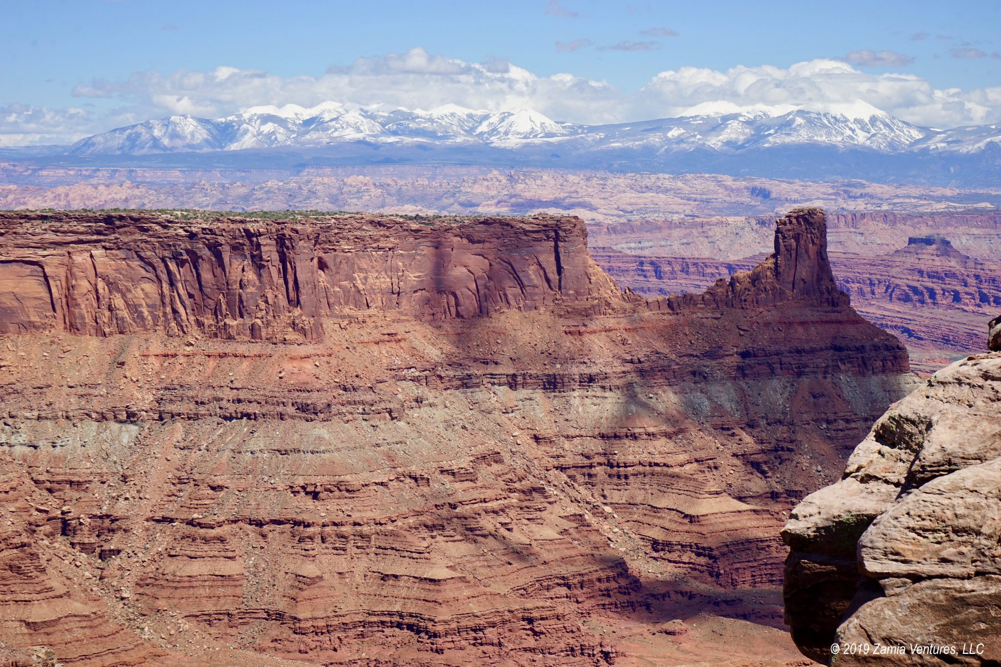
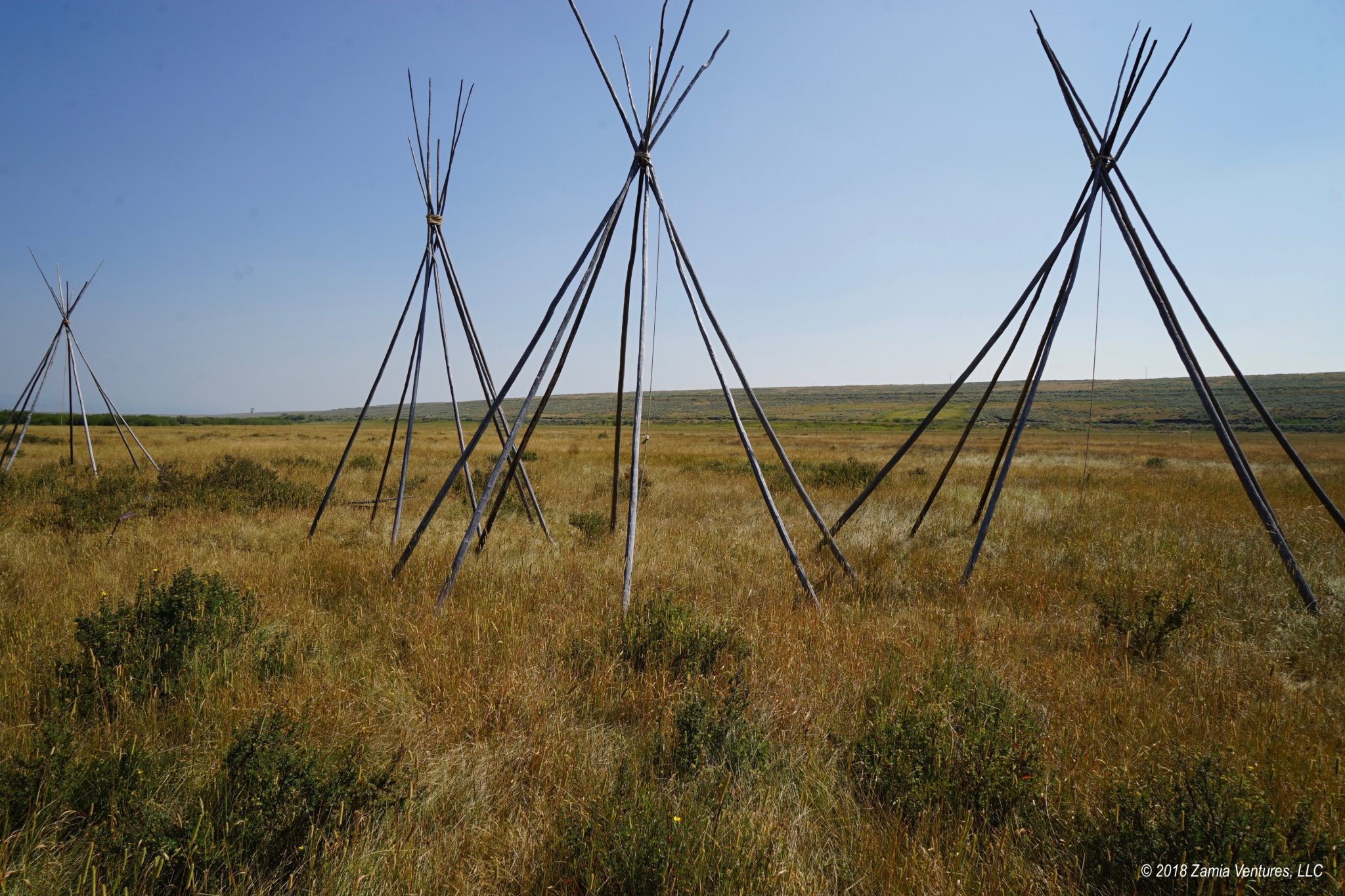
If you’ve ever seen a Jeep commercial or a western film, you already know what the region around Moab looks like. The red rock mesas with sheer vertical sides are some of the most familiar images of the American west. But while the sandstone formations were undoubtedly impressive, what really made it special for us was the snow-capped mountains in the background. The La Sal Mountains to the southeast, the Abajo Mountains to the south, and the Henry Mountains to the west added an even-more-unbelievable element to already indescribable landscapes. The area is so rich with natural features that we explored three separate phenomenal parks during our stay.
Plus, with a population of 5,000 people, the town of Moab is practically a booming metropolis — it is by far the largest community we encountered since passing through St. George, Utah on the way to Zion National Park weeks ago. That meant we could plan on doing laundry, visiting the public library to print things like our new auto insurance cards, shopping at a full-sized supermarket, and even visiting the state liquor store to purchase wine and real beer. Utah grocery stores are only permitted to sell beverages that are up to 4% alcohol by volume, which means just about anything other than light beer is in the domain of the state liquor stores.
Moab is a magnet for outdoor enthusiasts of all types. The mountain bike culture here is particularly epic. We regularly drove past dozens of trailheads between our campground and the town of Moab, and every single one of them was completely packed at every time of day on every day of the week. It was perfectly normal to see people in our campground, on hiking trails, in the grocery store, at the laundromat, and just walking around town wearing serious cycling gear from head to toe. The overwhelming majority of vehicles on the road had heavily laden bike racks. The exceptions were the off-road vehicles, which are part of the other major outdoor pursuit. I have never seen so many Jeep Wranglers in one place as here in Moab, and most of them had the giant tires and lifted chassis that’s the signature of an off-road vehicle. A significant part of the town traffic consists of people driving those 4-person dune buggy style off-highway vehicles. Even more noticeable are the wild Mad Max-style hybrids between Jeeps and/or old Ford Broncos and dune buggies. Complementing the bikers and the off-roaders are eclectic businesses ranging from multiple yoga studios to vegan restaurants to art galleries to a “barkery” selling all-natural pet foods. Needless to say, it was quite a change from the tiny agricultural communities we’ve been seeing across the rest of southern Utah.
Arches NP
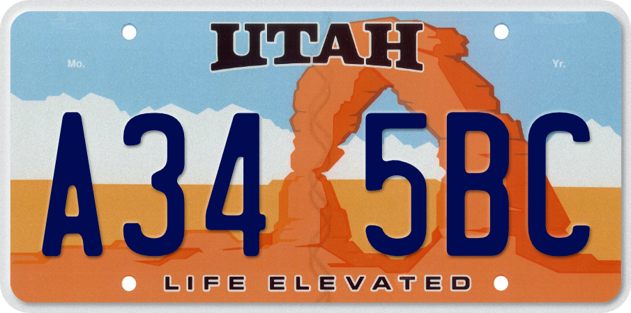
The most popular park in the area is Arches National Park and its main geological feature is right in the name: over 2,000 arches of varying sizes that have been eroded into the sandstone over millions of years. As explained by the park service introductory video and this page on the park’s website, quite a few different circumstances came together to create this density of arches. One is the porous sandstone that prevails in this area, which is particularly prone to erosion. Another is a historic uplift event that cracked the sandstone into thousands of narrow “fins” with parallel fissures between them. Each of these fins is an arch in the making, if the center is hollowed out by the forces of water and wind. The first destination we tackled in Arches was Delicate Arch. This is the most popular hike in the park, and the arch is so iconic that it appears on Utah license plates.
We thought that going on a day with a crummy weather forecast would limit the crowds at this site. We thought that by arriving at the park before 9 a.m. we would avoid long lines at the entrance station. We thought that by driving directly to the trailhead from the entrance, we would get out on the trail before it got too crowded. Sadly, all of these thoughts were completely wrong. Despite our relatively early start (and getting rained on) this was the most crowded hike we’ve experienced in months. The trail was just a constant stream of people headed in both directions, while the arch itself was surrounded by a gaggle of people waiting in a long line to have a solo picture under the arch.
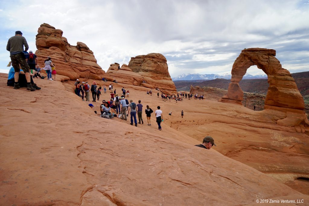
We’ve obviously been spoiled by our many, many miles on sparsely populated trails, because the constant parade of people along the trail so detracted from an otherwise nice hike that we both ended up hating it. I do my best thinking on the trail — including thinking about what to write in these posts — and being surrounded by groups of chattering people really intruded into my thoughts. At one point I had a group of hikers behind me carrying on a conversation about their culinary exploits that sounded like it was happening three inches behind shoulder. They droned on and on and on and on about their amazing and innovative process for making garlic bread. (Their method? Put garlic and butter on bread, then heat it on the grill. Or an oven could work. Genius, right??) After about five minutes of this completely inane conversation, I was ready to push the garlic bread people off the side of the hill. Fortunately for them I wasn’t raised by wolves, so I took a fake break and let them walk on by so I could escape the relentless mental intrusion of their lame conversation, only to have the next group behind them start chatting about something equally uninteresting. The mistake we made, of course, was in visiting the one location that “everyone” says you “have to see.” We should have already learned our lesson long ago that following our own preferences is a better recipe for happiness than just following the herd.
On our subsequent visit to Arches, we did a little better avoiding the crowds by selecting slightly less popular destinations but the park was still fairly packed. Nonetheless, it was fun to see a variety of arches and other formations in different sections of the park.


Despite the arches being the headline attraction at this park, we thought the most impressive formations were the massive sandstone monoliths near the park entrance in the Courthouse Towers area. The Park Avenue canyon features impossibly tall, thin fins that reach hundreds of feet into the sky in a surprisingly good facsimile of a New York City streetscape. There are plenty of balanced rocks (another favorite image of this park) and fins that have eroded into various fanciful shapes. And the scale of these formations is almost beyond comprehension. Squint at the photo of the Three Gossips below to find the car and RV traveling down the park road between the Three Gossips and the Organ. There are also people in the photo of Park Avenue: tiny little figures on the lighter colored sand along the canyon floor. So much for providing a sense of scale.


If we were to visit this area again, we would put more of a priority on visiting Arches at unusual times (very early morning or late afternoon) to avoid fighting for parking spots at the various viewpoints and trailheads, and to have a greater sense of solitude when taking in the sights. I’m not sure if the cause is the proximity to Moab — the park is just 5 miles outside of town — or the fact that most trails are short and easy, but Arches is apparently one of those parks that requires plenty of guile to avoid thundering herds of tourists.
Canyonlands NP
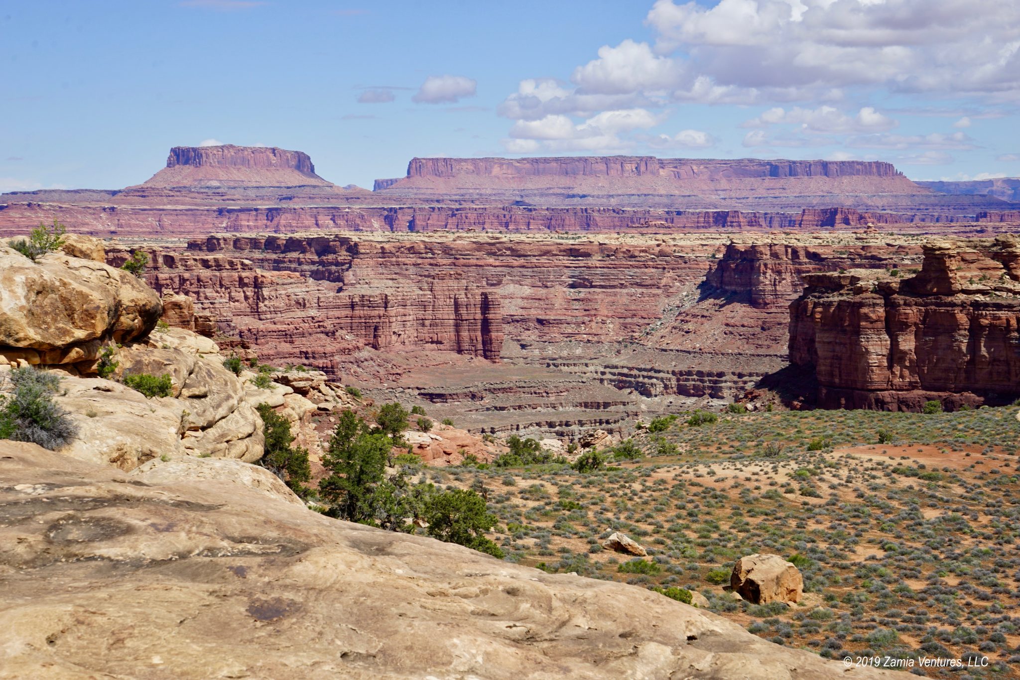
Meanwhile, just 30 miles from the entrance to Arches is the entrance to the Islands in the Sky district of Canyonlands National Park. It’s so close, yet seems a world away. The most obvious difference is the level of visitation. At Arches we sat in line for at least half an hour each time just to get through the entrance station (and there were two lines), while at Canyonlands we never had more than two or three cars ahead of us to get through the single file entry line. A little research on the NPS website reveals that Arches receives around 1.6 million visitors each year, while Canyonlands has never reached 800,000 in a single year. A few photos will quickly make it obvious why few people visit this park:


Terrible, right? The scenery at Canyonlands includes long, long views over dramatically eroded basins. Perched high on a mesa, the Islands in the Sky area looks out over valleys and plateaus carved by the Colorado and Green Rivers in much the same fashion as the Grand Canyon, except that the composition of the rock layers has led to many erosion remnants in the form of imposing vertical columns. The White Rim layer of sandstone, deposited almost 250 million years ago, is a harder sandstone that is more resistant to erosion, leading to a broad plateau below the main mesa top with its own network of cracks, gorges, and pillars.

Canyonlands also has a wider variety of trails than Arches, though we stuck to the relatively level ones that stayed on top of the mesa. The short (1 mile each way) but scenic Grand View Point Trail leads from the main park road out to the southern end of the mesa, offering views over the Green and Colorado River valleys and Junction Butte near the confluence of the rivers. The Aztec Butte Trail is also short (just over 1 mile) but takes hikers up the side of an extremely steep slickrock butte. This is probably the first trail we have attempted for which we felt that NPS description of “strenuous” was apt. The trail up the side of the butte is so steep — at times there is a 45% grade!! — that we were regularly using our hands to scramble up and brace ourselves on the way down. No photos from that one, since all four limbs were busy keeping me from falling off the side of the hill. We didn’t even make it fully to the top, since tumbling down a cliff and breaking limbs is not on our agenda for this trip, but still enjoyed the views and the adventure of the trail. The trail out to Murphy Point is around 3.5 miles round trip and offers lovely views to Grand View Point, Junction Butte, the Green River, and Candlestick Tower.


The best part about the trails here, besides the fantastic views, was that usually the only sound we heard was our own boots crunching along, and a few intermittent “Hellos” we exchanged with the handful of people we passed. And we hiked the easiest trails! There are plenty of trails that lead down into the canyons, which we left to those with an appetite for thousands of feet of elevation change. No doubt those routes are even less busy.
Oh, and this park only has one arch, but we thought it was pretty nice:
In our estimation, Canyonlands is every bit as impressive, jaw-dropping, and awe-inspiring as the Grand Canyon, but with only a tiny fraction of the visitors. Of course, it does attract the same type of lunatics who stand inches from the edge of a thousand-foot cliff just to snap selfies for Instagram, but I could avoid getting heart palpitations by simply choosing not to watch their antics and instead focusing on the incredible scenery around us.
Dead Horse Point State Park
For those who might worry that Los Federales have claimed all the good land in southeast Utah, the photo at the top of the post was taken from the visitor center at Dead Horse Point State Park, where we camped. Not too shabby, right? The state park sits on the same mesa as Canyonlands, on a different point jutting out above the canyons, about five miles up the road but closer as the crow flies. This means the views from the state park rival those of Canyonlands. As an illustration of how well this area stacks up to the Grand Canyon, this park was the shooting location for the final scene in Thelma & Louise, in which the car plunges into a canyon meant to be the Grand Canyon. It should come as no surprise that the hikes along the rim were outstanding. One day we explored the entire Rim Trail, a 5 mile loop around the entire point. Another day we headed out to the Big Horn Overlook, which was about 4 miles including the walk from our campground to the trailhead.


The Wingate campground where we stayed was practically brand new and in great shape. At $40/night, it was a little pricier than we would normally expect for a site with only an electric hookup, but the quality of services in this remote location made the price understandable. There is no way to dig a well up here, so the park trucks in water to provide drinking water and water for the (flush toilet) bathrooms and sinks. Over at nearby Canyonlands National Park, there is no water available at all in the campground or at the visitor center, which is really unusual, and all the toilets are pit toilets. We were happy to have our electric hookup since a few nights during our stay the temperatures dropped into the 30s in what we hope was the final burst of winter, and our small space heater was much appreciated.


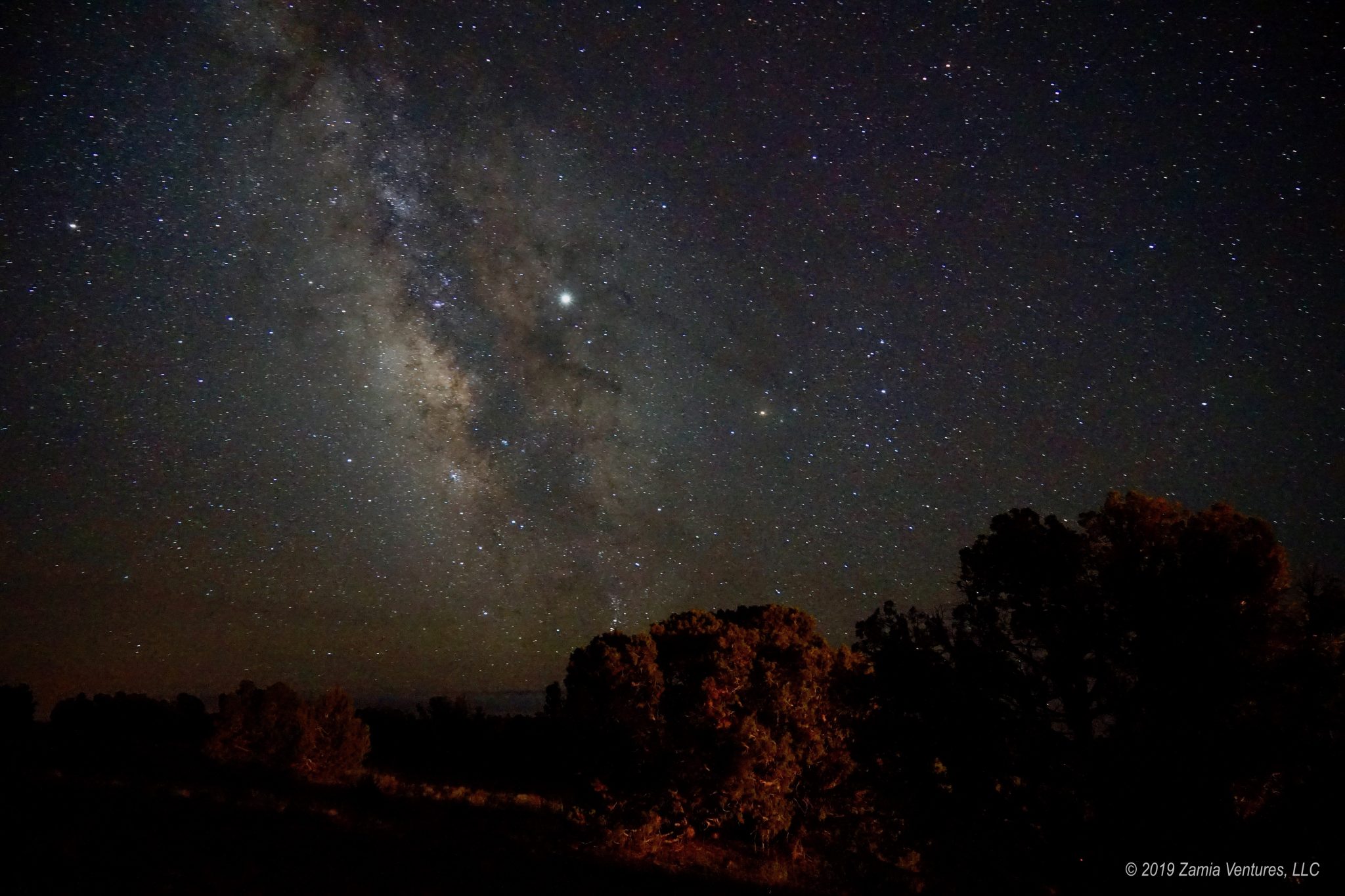
We had a new moon during our stay, and the very dark skies of southern Utah gave me the chance to work on my star photography skills. Clear skies and calm nights without wind made it possible to sit through lots of long exposure shots with the tripod set up on the tent pad right behind our campsite. After quite a bit of experimentation I finally captured a photo of the Milky Way that I’m pretty happy with:
Unfortunately we were slowed down this week because of illness. Just as I’ve finally recovered from a terrible cold, Ken has come down with a health challenge of his own. While my sickness was the sneezing/wheezing/runny nose/uncontrollable coughing variety, Ken has the kind that involves fever, chills, sweats, and being too exhausted to get out of bed. Apparently we offer something for everyone in the disease department. Assuming we don’t get quarantined by public health authorities first, our next week takes us south of Moab for our final exploration of Utah geological formations and (we hope) plenty of rest and recovery.
Hahaha…. I realize that for most visitors, getting to see these breathtaking natural wonders is a once in a lifetime experience, while for us, it’s just what we do on a Tuesday afternoon, but seriously? Could they just shut the hell up and get out of my way???? 🙂
I find the longer we do this, the less patience I have for others on trails and campgrounds and at tourist sites. I think it just happens over time. You get used to a certain amount of peace and quiet and being surrounded by others who have the same priorities. Then, the seasons change and you’re surrounded by vacationers and spring breakers and people who want to “do” the Might Five in 4 hours and, suddenly, mass murder seems like a reasonable solution.
In any case, we haven’t been to any of these locations, but they are all on the list. Your photos are gorgeous and we’ll certainly take your advice on what to focus on when we get there (though I will definitely still go see Delicate Arch…. I’ll just be sure to pack my patience that day….)
Hope you guys feel better soon.
I guess the one positive aspect of busy trails is that we get to mock the people hiking in flip flops, because there are always plenty of them on the really crowded trails, but waiting for them to tumble down the slickrock seems like a rather misanthropic form of entertainment. What also surprises me about the crowds is how many people don’t seem that involved in actually seeing the sights they have stood in line to see. Like the garlic bread people, I find so many of the members of big crowds are focused on all sorts of things besides the park and the natural wonders around them. Why bother coming all the way to these far-flung places if you’re going to spend the whole time chit chatting about other things and barely even looking at the scenery?
I am seriously bummed to hear that even in late April/early May that Arches is a zoo. When we first hiked Delicate Arch 15 years ago there were only a handful of people on the trail and very few people on any of the trails. When we returned for our third visit several years ago in late September it felt like we were at Disneyworld. You’ve been having such a wonderful time with so few people on the trails in all of the Utah parks that I was hoping it would be the same at Arches.
Okay, so it’s not. I’ll get over it. But I’m thrilled to see that you had such a peaceful time at Canyonlands. I know exactly what you mean about the delight of hearing only the crunch of your boots on the trail. (We hate hearing other people natter on about inane stuff when we’re hiking, too. Even worse is when they’re talking on their phones.)
Your photos are beautiful. We’re making our plans for next April/May, and hoping that we’ll be as fortunate as you have been with the weather. Hope you both feel all better soon!
Your description of Arches as Disney-like is apt. We felt the same way — and kept wondering if there was a way to get a FastPass and bypass the lines. 🙂
Here’s hoping you are also lucky with the weather next spring! It seems to be the most unpredictable time. We had several reports of snow in April in prior years in the places we visited, and we were expecting the worst after the unusually cold and snowy winter, but we really lucked out with the weather.
I am so happy we’ve already visited Arches and Moab because I just don’t think we could handle the crowds these days. Besides Zion, which we’ve also explored, I’m glad to hear that, for now at least, the others still offer some solitude — I guess we better hurry up! I did have to laugh at “garlic bread people” because it’s so funny how we describe strangers simply by snippets of their conversations or an article of clothing, etc.
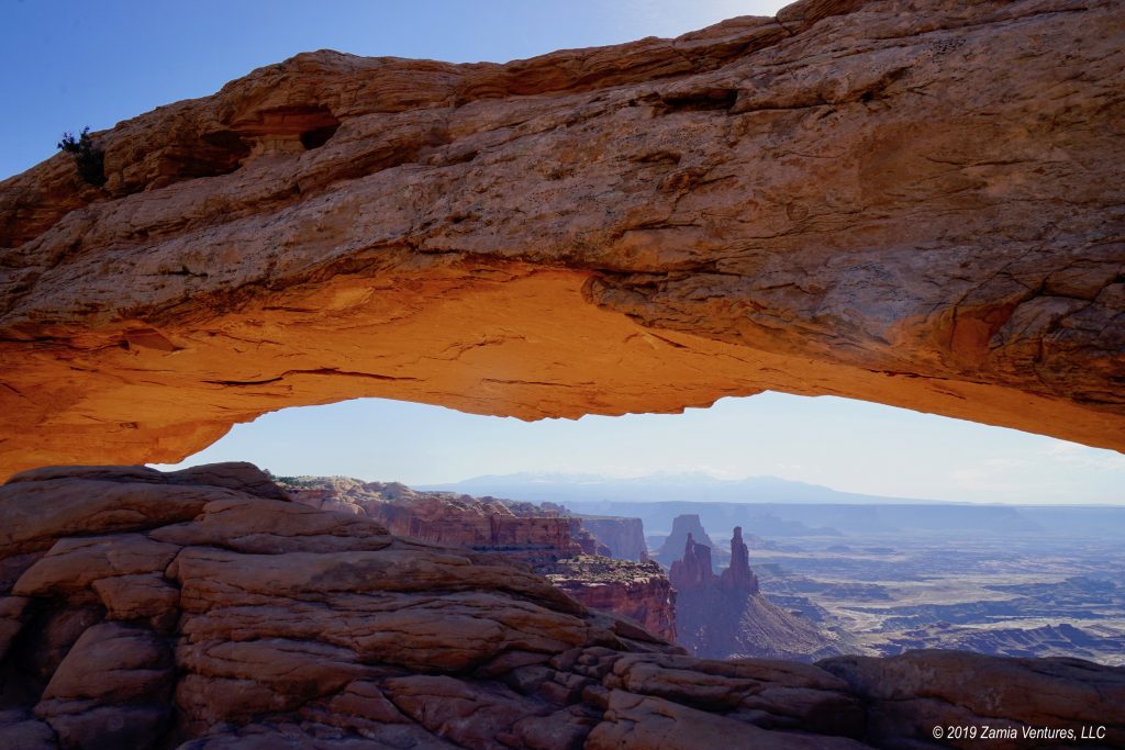
Really nice photo captures of the view through Mesa Arch and the Milky Way!
You could always try coming to Moab in January — I hear it’s not at all crowded then. Or you could just enjoy your memories from past visits, which seems like a better idea. It seems that Capital Reef and Canyonlands continue to fly under the radar for now, but who know how long that will last.
Thanks for the photo compliments. I like sleeping too much to regularly get up in the middle of the night for photo shots that require special light, so it’s nice to have the photos turn out well when I actually make some effort in that direction.