We weren’t really sure what to expect coming in to Capitol Reef National Park, which is probably the least famous of Utah’s Mighty 5 national parks, but it turned out to be a marvelous combination of all things Utah and an ideal place to spend a week. The historic Fruita settlement in the middle of the park has a free-flowing river, abundant trees and wildlife, and all the human-scale charm of the valley nestled in Zion National Park. Yet the main geological feature of the park, the Waterpocket Fold, is enormous, stretching 100 miles from north to south. Most important, the massive and colorful cliffs jutting up from the desert matched up perfectly with the images in my mind’s eye of “Utah rock formations.”
But first, we had to get there.
Scenic Byway 12
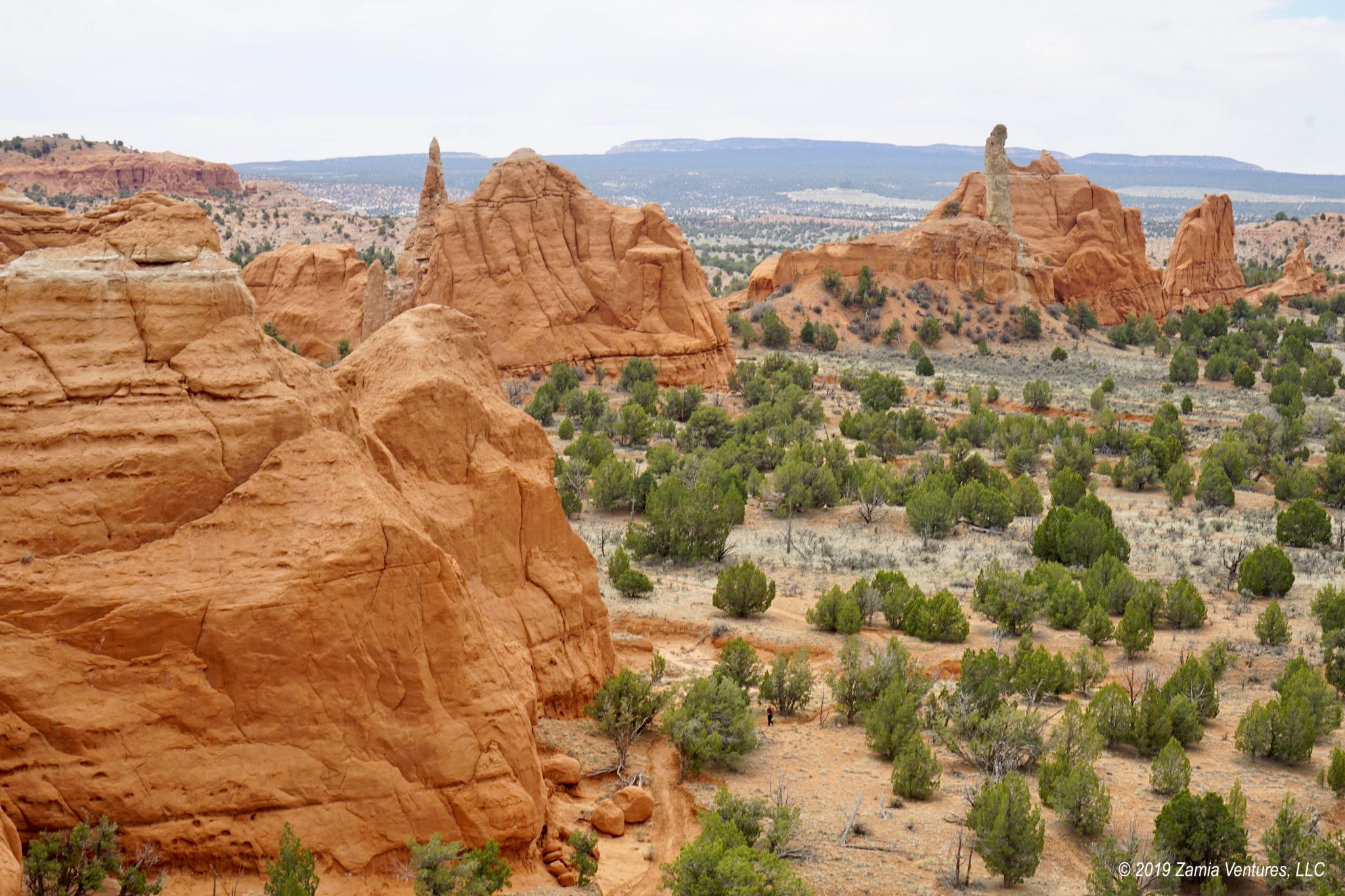
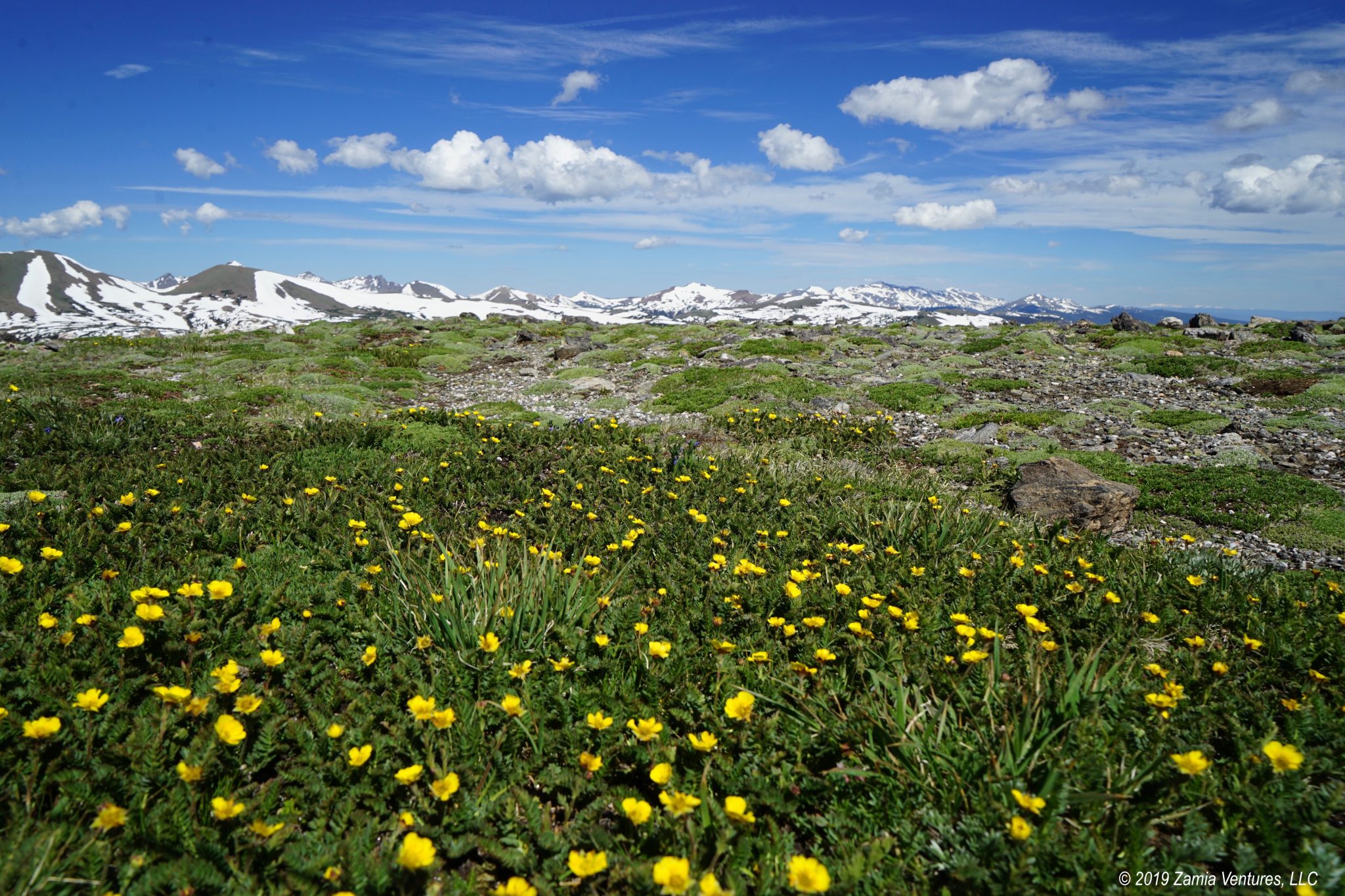
For our route from Kodachrome Basin to Capitol Reef, we chose the “direct” but slower route of Utah State Road 12, which is billed as Utah’s All-American Road. The road is mainly notable for its route through some of the most rugged and stunning landscapes in the continental U.S. In many places, the road winds through canyons of colorful rocks in the Dixie National Forest and the Grand Staircase-Escalante National Monument. But the big views come from on high, with ridge-top views across the vast and colorful plateaus. The road reaches 9,600 feet in elevation as it crests Boulder Mountain, where we found the road surrounded by snowbanks and delicate aspen trees with their striking white trunks. Scenic Byway 12 also passes through several small historic towns. It was encouraging to see all the businesses in Escalante catering to visitors to the surrounding national monument. It was also fun to drive through Boulder, considered the “last frontier in Utah” because this super-remote town was receiving its mail deliveries by horseback as late as 1935.


Although the road had plenty of severe curves and steep grades, it was definitely big-rig friendly. The frequent pull-outs and overlooks, wide lanes, and generous shoulders made us feel perfectly safe driving the route so long as we took it nice and slow. Unfortunately, my phone pictures really don’t do justice to the eye-popping scenery along this road.


Capitol Reef Explorations
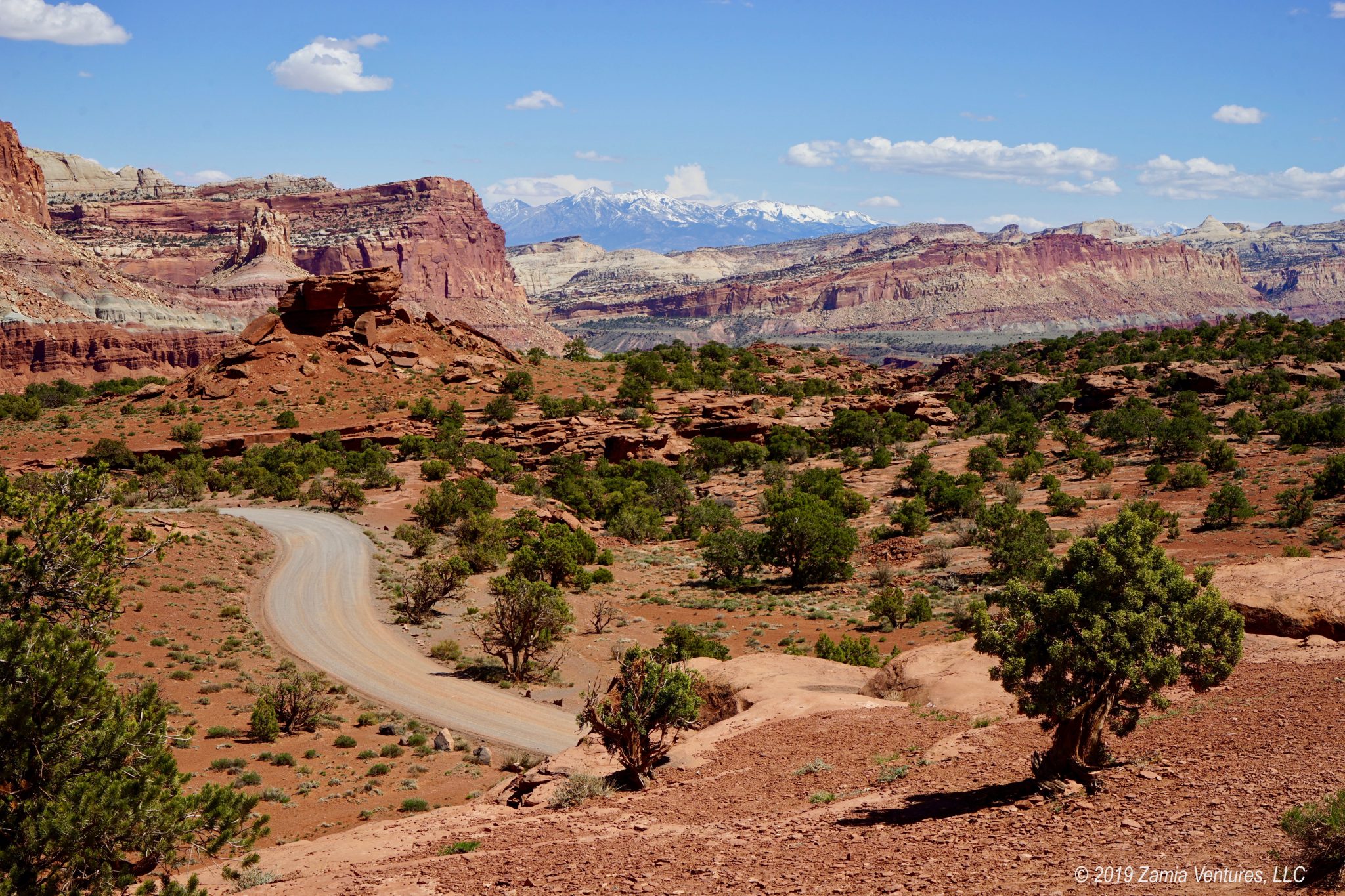
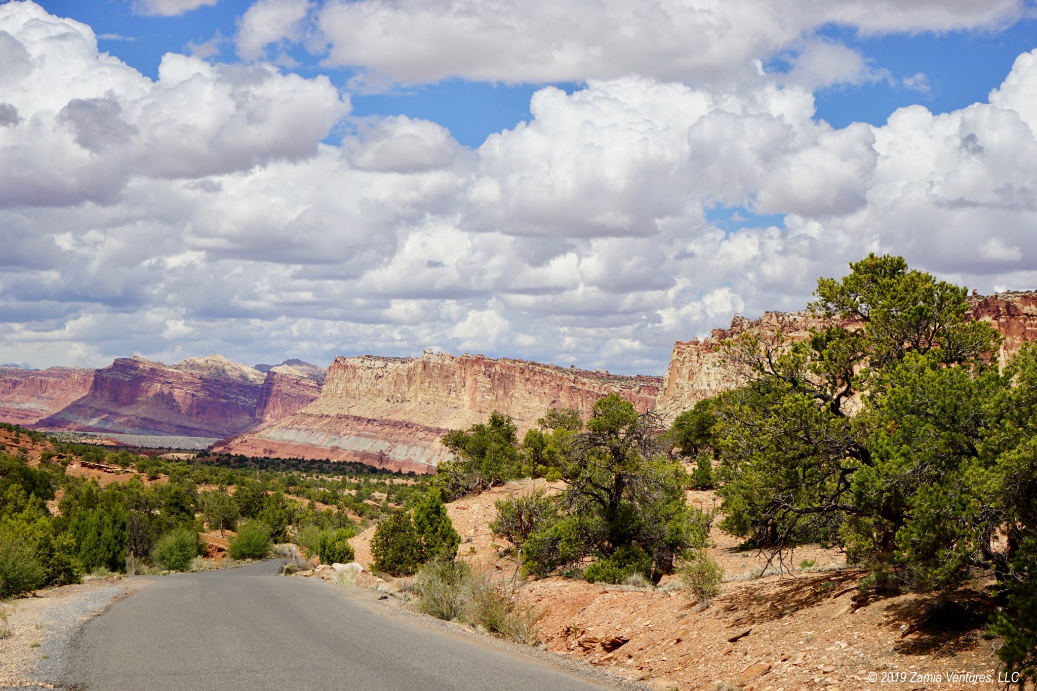
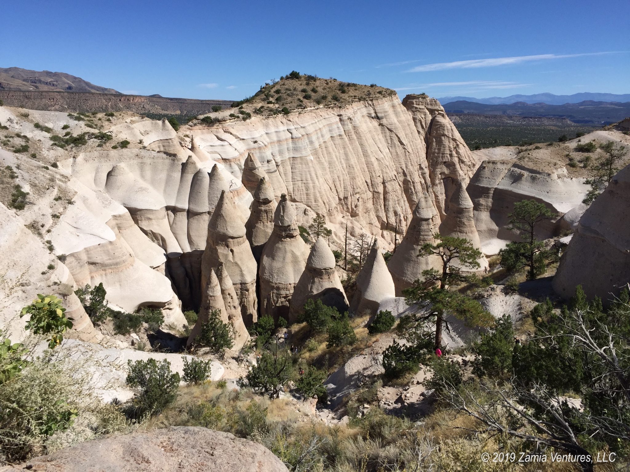
The Waterpocket Fold is a massive fold in the earth’s crust caused by the same uplift that created the Colorado Plateau. In this area, however, the rocks of the crust folded and buckled, so that when erosion began to expose lower layers the rocks that emerged jutted up to the sky in sharp angles, creating an imposing barrier to east-west travel. The scenic drive through the park provides breathtaking vistas of the massifs marshaled along the fold, and we had several chances to enjoy the views en route to various trailheads. The hikes here generally come in two flavors: hikes up and across mesas that offer sweeping views of the surrounding area, and hikes that involve exploring canyons. Even though our visit coincided with Easter, the trails were not at all crowded. We rarely saw more than a handful of other hikers, especially on the trails that included a fair amount of elevation change. We did see lots of wildflowers, and it was great to see Indian paintbrush, globe mallows, and assorted other flowers poking up from the narrowest of crevices in the rocks.
The Chimney Rock loop hike offered a wide variety of experiences in just about 4 miles of hiking. First, we headed up to the top of a cliff for absolutely stunning views toward the north, west, and south. The combination of nearby cliffs, then valleys and canyons plunging down, and distant ranges of snow-capped mountains was just gorgeous. Then the trail brought us right along the base of several brilliant red rock faces, where we could gape at the size of the sheer cliff faces reaching up to the sky above us, before returning to the trailhead.


The trail to Hickman Bridge was relatively short, clocking in at only around 2 miles, but the steep uphill section rewards hikers with a trip underneath a large and impressive natural arch. As usual, the long views along the canyons were filled with visual delights from chartreuse trees in the orchards along the river to massive colorful cliffs and domes. The beginning of the trail provides particularly nice views of the Capitol Dome, a white dome said to resemble the U.S. Capitol building and part of the inspiration for the park’s name.


The trail to the base of the Golden Throne features 2 miles of moderate but still very noticeable uphill incline, rising 700 feet as the trail winds along the side of Capitol Gorge. Most of the trail is across slickrock, but we found it to be well marked with cairns and rocks lined up along the side of the route. Around every bend are breathtaking views down the canyon and up to the surrounding cliffs. At the end, hikers are rewarded with views up to the Golden Throne formation (7,000 feet at its peak) and long views out from Capitol Gorge to the middle portion of the park (and the opportunity to go downhill for two solid miles). The dirt road from the scenic drive to the trailhead was one of the original roads in the park, making for an interesting historical perspective.


We hiked Cohab Canyon directly from our campground, and this was another relatively brief hike but filled with interesting shapes to explore in the pock-marked canyon walls. We hit the Grand Wash trail on a day that we wanted to take a break, and this mostly-level trail was perfect. It winds for about 4.5 miles round trip along a wash, only gaining/losing 200 feet of elevation each way as hikers wander through varying vistas. At times the canyon walls are open, with juniper-filled shelf areas that are reportedly favorite haunts of bighorn sheep. In other places the canyon walls are steep and relatively narrow, with those characteristic shapes of past scouring by flash floods.


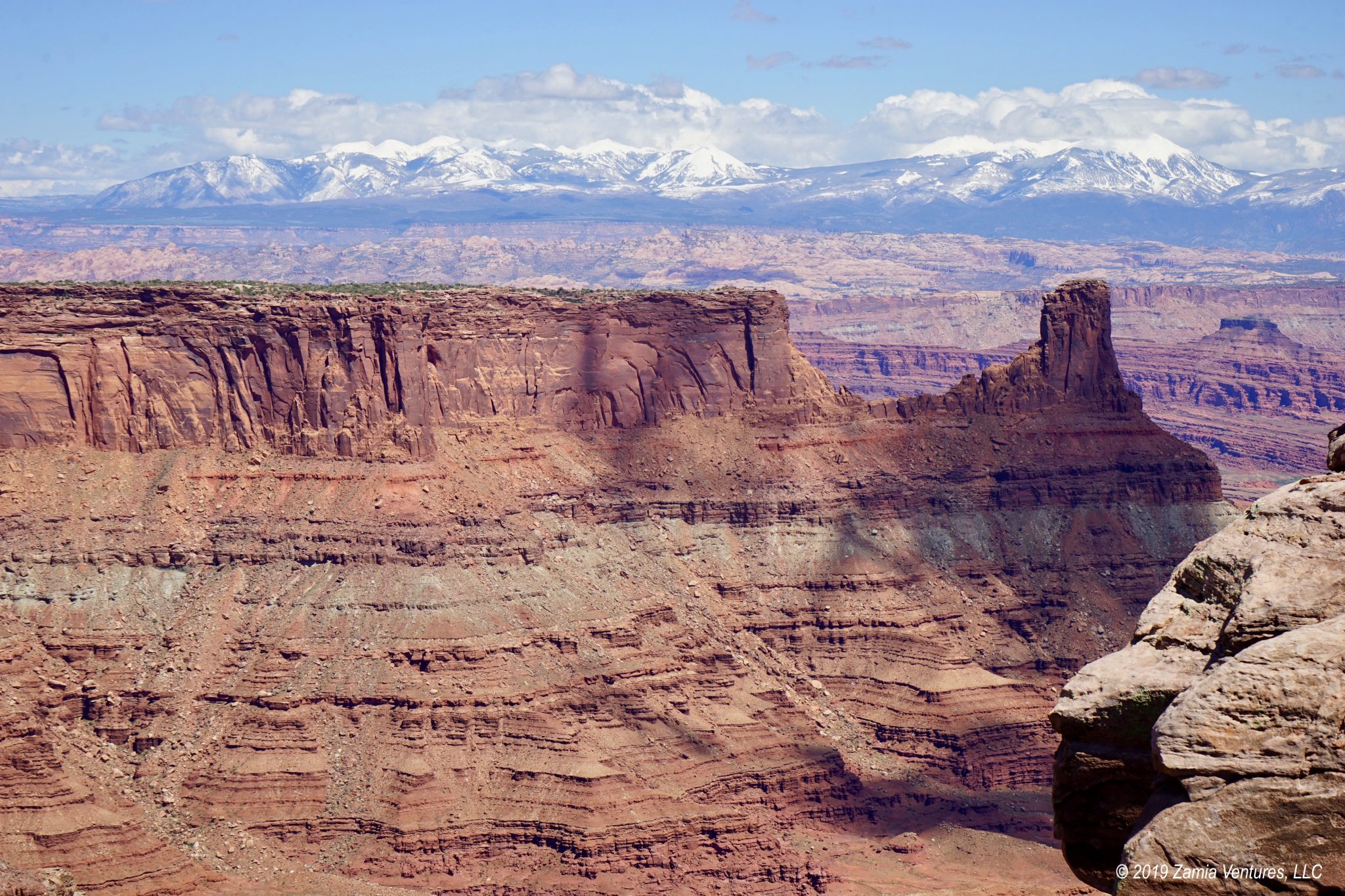
The most challenging hike we tackled was the Fremont Gorge Overlook. This trail first ascends to a mesa above Fruita, offering great views over the orchards and campgrounds, and then heads up a steep incline to a point looking west over the deep gorge carved by the Fremont River. The trail gains over 1,000 feet of elevation in about 2 miles (keeping in mind we are already in the thin air of 6,000 feet of elevation to begin with), and the steepest climb is reserved for the last three-quarters of a mile. That last stretch was an absolute killer, but at least the trail offered consistently amazing panoramic views as a reward for all our hard work. The Fremont Gorge Overlook and Chimney Rock routes ended up being our most demanding trails, but also the most rewarding in terms of awe-inspiring views of the main formations of the Waterpocket Fold.


There is no question that this park is a hiker’s paradise, and we found so much to do in the immediate vicinity of Fruita that we never explored the outlying areas of the park. The park stretches 100 miles north and south, and in the outer reaches are numerous scenic roads (mostly for high clearance, 4WD vehicles only) and noteworthy canyons to explore. We stayed at Capitol Reef for a week, and never came close to running out of things to do. We also never stopped being struck dumb at the sheer magnitude and beauty of the scenery in this park.
Fruita Camping
The campground located in the national park recently converted from first come, first serve (boo!) to reservations (yay!), and when we planned our swing through Utah we were happy to snag a week here. The campground is nestled in the lush and green Fruita Historic District. Fruita was founded by Mormon pioneers drawn by the year-round water flow of the Fremont River and the relative warmth and shelter provided by high cliffs surrounding the river valley. The small community soon developed thriving fruit orchards which gave the area its name – and which are still here. In late summer and fall national park visitors are invited to wander through the orchards and eat apples, pears, peaches, plums, and other fruits right off the trees. During our visit, it was lovely to see blossoms covering the orchards in preparation for another successful year of fruit production. The campground itself is nicely treed, and the surrounding orchards have plenty of ancient specimens, but the really impressive trees are huge, gnarled cottonwoods along the Fremont River that must date back to the time of the pioneers.


The national park preserves the pioneer heritage of the community in several structures, including the schoolhouse, blacksmith shop, and several barns and homesteads. The historic farm equipment and horses ambling around in fields helped create a pastoral ambience. The Gifford House, the home of the last family to actually live in the park, has been turned into a food-oriented store that supports the park. The wares for sale include traditional foods like local honey, relishes, pickled vegetables, and butters (apple butter, sweet potato butter, etc.), along with aprons, embroidered goods, hand-made wooden cooking utensils, many different cookbooks featuring pioneer recipes, and unique items like jewelry made from parts of Ball mason jars. It was fun to poke around the varied offerings of the store, but without a doubt the best part was the fresh foods: the store opens daily at 8 a.m. stocked with fresh cinnamon buns and fruit pies delivered from a local bakery.


Normally we are not that excited about historical re-enactments, but when fresh pie and cinnamon buns are involved, I will be the first to tie on a 19th century bonnet! I am obviously not the only one who feels this way, because we heard the cinnamon buns may sell out as early as 8:15 a.m. Being camped a short stroll away meant we were able to get over there early and see what all the fuss was about. Those dessert-plate-sized cinnamon rolls were delicious and clearly earned the hype. They also had important medicinal qualities: they helped eradicate the last symptoms of my terrible cold. Or at least that’s what I told myself. The 6-inch fruit pies were perfect for us to split as a dessert but they could just as easily have been a post-hike snack.


Overall, Capitol Reef really hit all the marks for us. The hikes featuring big landscape views left us gaping in wonder, while the stream and canyon explorations offered a sense of adventure and fun. And of course it helped that our weather was almost continuously perfect. Sunny days with high temperatures in the 70s and overnight lows in the upper 40s were exactly what we hoped for when we planned to spend the month of April exploring Utah’s Mighty 5. Abundant sunshine also meant that we didn’t need to worry about our ability to generate solar power. But what made Capitol Reef really outstanding was the contrast between the harsh desert environment and the lush campground at Fruita. After spending every morning exploring rocky desert terrain on one of the park’s many excellent hikes, it was so refreshing to spend the afternoons reading at camp, listening to the sounds of birdsong, the rushing Fremont River, and the cottonwood leaves ruffled by the breeze.
Next, we head to the Moab area to finish up the Mighty 5.
Oh, how gorgeous! We haven’t spent near enough time in Capitol Reef and have promised ourselves a return trip. Your post definitely moved the park up on our list. We stayed at the Fruita campground in the fall, harvested apples, and oh! delight! baked an apple crisp in our first trailer oven. Which makes me realize that the last time we were there was about a dozen years ago.
Visiting in the spring with the fruit trees in bloom sounds wonderful. And to have the trails to yourselves, even on Easter weekend, is amazing. Thanks for all of the great hiking ideas—the only trail I remember hiking was that killer one above the campground. I believe we just might follow in your footsteps next April!
It sounds like spring and fall are the very best times to visit Capitol Reef. We were pretty surprised by the fact that the trails were relatively quiet, especially since there were tons of families having picnics in the Fruita area and visiting Gifford House, even on weekdays. I guess the normal predictions about national park visitors hold true even at Capitol Reef: walk 1/2 mile from a parking area and you will leave 80-90% of the other visitors behind.
Love the fruit pies there. Unsurprisingly, the Andersons have never arrived early enough to score a cinnamon bun. Now we’ll just have to go back!
Well, the pies make for a pretty great consolation prize if you miss the cinnamon buns. But I can say for certain that having BOTH is the way to go. 🙂
Utah really does have the most dramatic scenery, as your photographs so clearly demonstrate. These views are just epic! I’ve never understood why Capitol Reef and Canyonlands seem to be the ‘forgotten’ parks, but I guess it’s nice to have a couple that aren’t overrun by tour buses. And I can totally see the benefit of coming back to a green, leafy campground after a day out in the rocky scenery. As much as I love the desert, I miss trees and grass when we’re out there too long. And, speaking of things we all miss when we’re away too long, pie…. Mmmmmmm, pie…. I firmly believe that ALL pie is awesome, but THAT pie that you had looks incredible!! I would hike through the desert for that any day of the week!
We were also surprised the park lacks much of a reputation, since it has such mind-blowing views and a marvelous camping situation. It might be the fairly significant isolation from towns of any meaningful size. Come to think of it, that may also explain why people there have developed the ability to produce their own amazing baked goods as well. Self-sufficiency for the win!
What a contrast between the leafy orchards and the barren cliffs. Beautiful photos! Looks like heaven for geologists. I would visit just for the fruit pies and the cinnamon rolls 😀
I agree 100%. Come for the fascinating geology and beautiful rock formations, stay for the baked goods!
I sure hope by the time we get to visit Capitol Reef it is still one of the least-visited and that they still have pie and cinnamon buns! That whole place from the stunning red rock hiking to the soft green lushness of the campground sounds like paradise. Can’t wait to follow in your footsteps — literally!
As far as I can tell, the sales of cinnamon buns and pie are enough to fill about 25% of the entire National Park Service budget so I don’t see this store closing down anytime soon. Plus, they’ve been making pie here for 100 years, so I think you can safely assume it will still be there when you visit. It’s well worth a visit, especially given your love of hiking! There is something here for every skill level, and we barely scratched the surface in a week.